

 |
The remaining floodplains and wetlands of the Danube basin are unique ecosystems of European and partly even global importance (the karst and the delta). The fluctuating river discharge is the determining factor for life along the river banks and adjacent floodplains. The living spaces created by the Danube and its tributaries host a unique diversity of species, with about 2,000 higher plants and more than 5,000 species of animals (including 41 mammals, 180 breeding birds, 100 fishes, eight reptiles and twelve amphibians). The remaining large floodplain forests and the Danube Delta are last refuges in Europe for the white-tailed eagle and the white pelicans, the beaver was successfully reintroduced. |
|
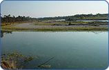
In addition, there are some special ecosystems such as lakes (Neusiedl, Balaton, Liman etc.), moors, marshes, drylands (puszta, sand dunes) and the karst, all connected to water forces and home to partly endemic fauna and flora. Many of these species require very special living conditions in terms of velocity, turbidity, depth, temperature and nutrient values of water, or in terms of eroded banks, gravel beds and dead tree trunks. Intact water dynamics (regular low water and inundation periods) and open connections between side-arms and the main bed are crucial conditions for their life-cycles (e.g. feeding, reproduction, sheltering, migration). |
 |
During the last two centuries in particular, most large floodplain areas within the Danube basin have disappeared. Primeval riverine forests, which take some 6.000 years to develop, are almost extinct in Europe. Since these were the most fertile and productive areas, they were the first to be settled; their resources were used early on (e.g. for hunting, fishing, boat building) and they were the site of vigorous economic activities (timber, hay and various products from arable lands). Later, the wild rivers were "tamed" to increase flood protection, navigation, agricultural production, and to allow energy production. Such interference has, for instance, shortened by 21% the length of the Bavarian Danube and from 1,419 to 966 km the length of the Tisza river in Hungary. About 3.7 million hectares of permanently or seasonally inundated land were diked in Hungary in the 19th and 20th century, and in Romania in the 1960s and '70s, 435,000 ha (80%) of the floodplains were diked to allow intensive agriculture. |
|
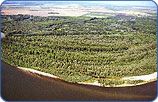
Today, only a few floodplain areas are still near-natural. They include large parts of the Danube Delta, along the lower Prut river, several Bulgarian Danube Islands, the central Sava, the Gemenc - Kopacki Rit border area (H-HR-YU), the lower stretches of the Mura and Drava rivers (A, HR, H), the Danube-Morava-Dyje floodplains between Vienna, Bratislava and south-east Czech Republic, and the mouth of the Isar river in eastern Bavaria. Many floodplain areas are protected as nature reserves, national parks, biosphere reserves, Ramsar sites and Important Bird Areas, but at the same time, they are subject to degrading river bed erosion, pollution, intensive forestry and hunting, intensive recreation etc. |

