

 |
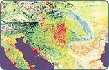
The Danube River raises at the confluence of the two source river Brigach and Breg near Donaueschingen in the Black Forest in Germany. However, by agreement the source of the Danube is considered a spring in the castle of Donaueschingen. The Danube River is 2778 km long (from confluence of the Breg and Brigach) and drains 817000 km² with a mean annual water volume of 6550 m3/s discharged into the Black Sea. Out of the 18 countries in the Danube River Basin, 13 countries have substantial territory within the basin. The basin area includes all of Hungary; nearly all parts of Austria, Romania, Slovenia, Slovakia and FR Yugoslavia; significant parts of Bosnia - Herzegovina, Bulgaria, Croatia, the Czech Republic, Moldova and small parts of Germany and Ukraine. Switzerland, Italy, Poland, Macedonia and Albania have areas smaller than 2000 km². The Danube River discharges into the Black Sea through a delta that represents the second largest natural wetland in Europe. The Basin is characterised by an aquatic ecosystem with numerous important natural areas, including wetlands and floodplains. It is not only of a high environmental but also economic and social value. It supports the drinking water supply, agriculture, industry, fishing, tourism and recreation, power generation, navigation and the end disposal of wastewater. A large number of dams, dikes, navigation locks and other hydraulic structures have been built throughout the region. Utilizing water resources for important human activities, such as municipal ones, industry and agriculture, has resulted in changes in the hydrological systems. Problems of water quality and quantity have been created, including significant environmental damage and impaired quality of life. The Danube River Basin can be divided into four parts:
THE UPPER REGION |
 |
extends from the source of the Danube River to Bratislava. After the confluence of the two source rivers Brigach and Breg the Danube River follows the fault gap of the German Alb. Major tributaries from the south, including the rivers Iller, Lech, Isar, Inn, Salzach, Traun and Enns, drain the alpine sub-basin and augment the discharge in the Danube substantially. The Morava River is in this region the most important river from the north, draining the Czech part of the DRB and smaller areas of Slovakia and Austria. THE MIDDLE REGION |
 |
is the largest of the three regions, extending from the confluence with the river Morava at Bratislava to the Iron Gate dams. Here the river enters a flatland region. The major tributaries in this region are:
From Moldova Veche the river flows through a 117 km long gorge between the Carpathiens and the Balkan mountains, which has been filled up by large reservoirs for the purpose of hydro-power utilization and navigation. THE LOWER REGION |
 |
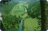
is formed by the Romanian-Bulgarian lowlands and their surrounding upland plateaus and mountains. From the mouth of the river Timok to Silistra the Danube forms the Romanian-Bulgarian border, flowing mostly east. In this region the Danube is a wide, slow-moving river with extensive, well developed alluvial plains especially on the left- bank Romanian side; the right-bank Bulgarian side is a narrow riverine plain flanked by a steep bank. Few of the tributaries in the lower region influence the hydrology of the Danube River. Although many of them have large catchment areas, their flow is small in comparison to that of the main river. The last two large left-bank tributaries are the Siret and Prut rivers. THE DANUBE DELTA |
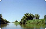 |
is largely situated in Romania and partly in Ukraine. The entire protected area covers 679,000 ha including floodplains and marine areas. The core of the reserve (312,400 ha) has been established as a "World Nature Heritage" in 1991. The Delta has a canal network of 3,463 km, with a density of 1.03 km/km². The highest density of canals is between the arms Chilia and Sulina, 1,17 km/km², while between Sulina and Sf. Gheorghe their density is only 0.71 km/km². There are 668 natural lakes larger than one hectare and with 9,28 % of the Delta's surface. The Delta is an environmental buffer between the Danube River and the Black Sea, filtering out pollutants and permitting both water quality conditions and natural habitats for fish in the Delta and in the environmentally vulnerable shallow waters of the north-western Black Sea. Moreover, it is Europe's largest remaining natural wetland, with unique ecosystems with extensive reed beds, forests, sand dunes and grasslands. It is home to several rare bird species, an important resting point for migrating birds, rich in fish and unusual flora. |
| River |
Mouth at Danube km |
Length in km |
Size of Sub-basin in km² (larger than 4,000 km²) |
Min Flow (m³/sec) |
Max Flow (m³/sec) |
Avg Flow (m³/sec) |
| Lech | 2,496 | 254 | 4,125 | 114 | ||
| Naab | 2,384 | 191 | 5,508 | 54 | ||
| Isar | 2,282 | 283 | 8,964 | 173 | ||
| Inn | 2,225 | 515 | 26,13 | 727 | ||
| Traun | 2,125 | 146 | 4,277 | 118 | ||
| Enns | 2,112 | 349 | 6,08 | 190 | ||
| Morava (CZ) | 1,88 | 340 | 26,642 | 45 | 229 | 110 |
| Raba | 1,794 | 240 | 14,83 | 80 | ||
| Vah | 1,766 | 398 | 19,131 | 152 | ||
| Hron | 1,716 | 260 | 5,439 | 54 | ||
| Ipel | 1,708 | 140 | 5,145 | 17 | ||
| Sio | 1,498 | 124 | 14,8 | 30 | ||
| Drava | 1,382 | 893 | 40,076 | 670 | ||
| Tisza | 1,214 | 966 | 157,186 | 380 | 1,785 | 813 |
| Sava | 1,17 | 861 | 100,59 | 1,022 | 2,56 | 1,513 |
| Morava (YU) | 1,103 | 430 | 37,597 | 236 | ||
| Timok | 846 | 180 | 4,6 | 15 | ||
| Jiul | 692 | 240 | 9,2 | 80 | ||
| Iskar | 636 | 400 | 8,437 | 28 | ||
| Olt | 604 | 542 | 23,282 | 160 | ||
| Yantra | 537 | 271 | 7,85 | 24 | ||
| Arges | 432 | 270 | 9,2 | 80 | ||
| Ialomita | 244 | 270 | 9,9 | 70 | ||
| Siret | 159 | 520 | 44 | 300 | ||
| Prut | 134 | 950 | 27,447 | 150 |

